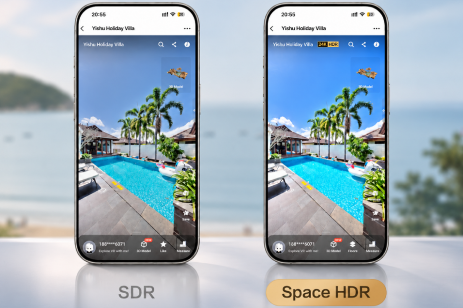
Combining professional LiDAR hardware, intelligent software and immersive imaging, Realsee is making spatial digitization more realistic, accessible and practical across industries.
Hong Kong, China, Nov. 06, 2026 (GLOBE NEWSWIRE) — Digital twins are changing how people discover properties, plan renovations, document buildings and collaborate remotely. But the value of spatial technology goes beyond capturing a space in 3D. Professionals need reliable data, efficient workflows and digital experiences that communicate the details of a real environment.
This thinking shapes Realsee’s approach to innovation. Rather than treating 3D capture as a standalone hardware task, the company is developing an integrated ecosystem connecting capture, reconstruction, editing, collaboration and sharing. Its latest imaging advancement, Space HDR, reflects this ambition: to make digital spaces more lifelike and professional spatial tools easier to use.
Space HDR: Bringing Real-World Lighting into Digital Spaces
High dynamic range imaging has traditionally improved individual photographs. Bringing that experience into a navigable 360-degree environment is more complex: bright areas near windows, shadowed corners and mixed lighting all need to retain natural detail as viewers move through a space.
Realsee’s new Space HDR technology extends HDR imaging into immersive 3D tours, helping preserve highlight detail, retain detail in shadowed areas and deliver more natural colors. The result is a viewing experience that better reflects how a space appears in real life, whether it is a sunlit apartment, a hotel lobby or a museum.
Behind the experience is substantial engineering work. Realsee has redesigned its browser rendering engine around WebGPU and developed an imaging workflow connecting capture, processing, compression and display. Using Gain Map technology based on ISO 21496-1, Space HDR enables enhanced HDR presentation on compatible devices while maintaining SDR compatibility on other screens. Viewers can access the experience directly in a browser, without installing a separate application.
Professional Capture, Designed for Different Needs
Space HDR is one part of Realsee’s wider investment in LiDAR technology, computational imaging, computer vision and spatial reconstruction. These capabilities are reflected in the Galois product family, which combines high-resolution panoramic imaging with LiDAR capture for different professional workflows.
The Galois P4 is designed for projects that demand detailed spatial documentation. It captures 24K panoramic imagery at approximately 300 megapixels and supports scanning distances of up to 100 meters. Its LiDAR acquisition rate reaches 125,600 points per second, while measurement accuracy is within ±10 mm at distances of 0.1–15 meters under specified conditions. These capabilities support AEC documentation, commercial properties and high-end property photography.
The Galois M2 brings panoramic imaging and LiDAR scanning together in a portable, all-in-one device. With 16K panoramic imaging, it supports indoor and outdoor capture across real estate, hospitality and other spatial documentation scenarios. Realsee’s broader portfolio also includes handheld and mobile capture options, allowing users to choose a solution that fits their project scale, working style and budget.
From Capture to Usable Digital Assets
For Realsee, the camera is only the starting point. Its integrated platform transforms captured data into interactive 3D tours, high-resolution panoramas, floor plans, point clouds, 3D models and other deliverables.
AEC professionals can use E57 point-cloud exports in downstream documentation and Scan-to-BIM workflows. Real estate and hospitality teams can publish browser-based virtual tours that let clients explore properties and venues remotely. With the 3D Tour Editor, users can refine tours, add relevant on-tour information and share completed experiences.
Connecting hardware, reconstruction technology and cloud-based tools helps users get more value from each capture. A single scan can support a property presentation, design review or building documentation, reducing the need to repeat work for different purposes. Realsee’s flexible pay-as-you-go credit model also lets customers access hosting and selected services according to their needs, without a mandatory fixed monthly software subscription.
Innovation That Starts with the User
Realsee’s development philosophy is grounded in a simple principle: technology should solve practical problems. That means improving image quality while keeping workflows straightforward, delivering accurate spatial data that is easier to share, and developing tools for both specialist teams and professionals new to 3D capture.
The Galois product family has received international design recognition, including the Red Dot Design Award and the Good Design Award (G-Mark). Realsee also makes product conformity documentation available to support customer understanding and confidence.
As spatial technology becomes increasingly relevant across real estate, architecture, construction, hospitality and cultural heritage, Realsee continues to invest in hardware and software that help more people capture, understand and communicate physical spaces.
Making Innovation More Accessible
Realsee believes advanced spatial technology should be within reach of more professionals. As part of this commitment, the company is preparing a special Black Friday campaign, giving customers an opportunity to explore its 3D capture solutions with exclusive offers.
To learn more about Realsee’s products and spatial digitization solutions, visit www.realsee.ai.
From LiDAR accuracy to immersive Space HDR viewing, Realsee’s direction remains consistent: combining continuous technological innovation with practical tools that make the physical world easier to capture, experience and work with.
CONTACT: Amber Zhong, zhongchuyue001@realsee.ai
Source: GlobeNewswire